Selected NASA Europa Images
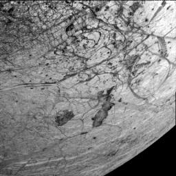 This image of Europa's southern hemisphere was obtained by the solid state imaging (CCD) system on board NASA's Galileo spacecraft during its sixth orbit of Jupiter. The upper left portion of the image shows the southern extent of the 'wedges' region, an area that has undergone extensive disruption. South of the wedges, the eastern extent of Agenor Linea (nearly 1000 kilometers in length) is also visible. Thera and Thrace Macula are the dark irregular features southeast of Agenor Linea. This image can be used by scientists to build a global map of Europa by tying such Galileo images together with images from 1979 during NASA's Voyager mission. Such lower resolution images also provide the context needed to interpret the higher resolution images taken by the Galileo during both its nominal mission and the upcoming Europa mission.
North is to the top of the picture and the sun illuminates the surface from the right. The image, centered at -40 latitude and 180 longitude, covers an area approximately 675 by 675 kilometers. The finest details that can discerned in this picture are about 3.3 kilometers across. The images were taken on Feb 20, 1997 at 12 hours, 55 minutes, 34 seconds Universal Time when the spacecraft was at a range of 81,707 kilometers.
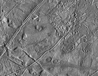 This complex terrain on Jupiter's moon, Europa, shows an area centered at 8 degrees north latitude, 275.4 degrees west longitude, in the trailing hemisphere. As Europa moves in its orbit around Jupiter, the trailing hemisphere is the portion which is always on the moon's backside opposite to its direction of motion. The area shown is about 100 kilometers by 140 kilometers (62 miles by 87 miles). The complex ridge crossing the picture in the upper left corner is part of a feature that can be traced hundreds of miles across the surface of Europa, extending beyond the edge of the picture. The upper right part of the picture shows terrain that has been disrupted by an unknown process, superficially resembling blocks of sea ice during a springtime thaw. Also visible are semicircular mounds surrounded by shallow depressions. These might represent the intrusion of material punching through the surface from below and partial melting of Europa's icy crust. The resolution of this image is about 180 meters (200 yards); this means that the smallest visible object is about a quarter of a mile across.
This picture of Europa was taken by Galileo's Solid State Imaging system from a distance of 17,900 kilometers (11,100 miles) on the spacecraft's sixth orbit around Jupiter, on February 20, 1997.
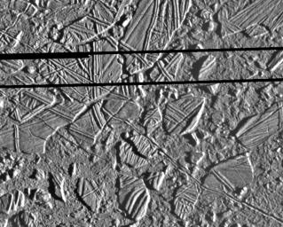 This high resolution image shows the ice-rich crust of Europa, one of the moons of Jupiter. Seen here are crustal plates ranging up to 13 kilometers (8 miles) across, which have been broken apart and "rafted" into new positions, superficially resembling the disruption of pack-ice on polar seas during spring thaws on Earth. The size and geometry of these features suggest that motion was enabled by ice-crusted water or soft ice close to the surface at the time of disruption.
The area shown is about 34 kilometers by 42 kilometers (21 miles by 26 miles), centered at 9.4 degrees north latitude, 274 degrees west longitude, and the resolution is 54 meters (59 yards). This picture was taken by the Solid State Imaging system on board the Galileo spacecraft on February 20, 1997, from a distance of 5,340 kilometers (3,320 miles) during the spacecraft's close flyby of Europa.
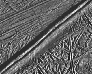 This view of the icy surface of Jupiter's moon, Europa, is a mosaic of two pictures taken by the Solid State Imaging system on board the Galileo spacecraft during a close flyby of Europa on February 20, 1997. The pictures were taken from a distance of 2,000 kilometers (1,240 miles). The area shown is about 14 kilometers by 17 kilometers (8.7 miles by 10.6 miles), and has a resolution of 20 meters (22 yards) per pixel. Illumination is from the right (east). The picture is centered at about 14.8 north latitude, 273.8 west longitude, in Europa's trailing hemisphere.
One of the youngest features seen in this area is the double ridge cutting across the picture from the lower left to the upper right. This double ridge is about 2.6 kilometers (1.6 miles) wide and stands some 300 meters (330 yards) high. Small craters are most easily seen in the smooth deposits along the south margin of the prominent double ridge, and in the rugged ridged terrain farther south. The complexly ridged terrain seen here shows that parts of the icy crust of Europa have been modified by intense faulting and disruption, driven by energy from the planet's interior.
These images were obtained from NASA's Galileo web site at http://www.jpl.nasa.gov/galileo.
Send comments and suggestions about this page to:
Dr. Charles S. Tritt
This page last updated 7/18/97